I’m a genius.
Which most of us already knew, so I’ll get to the point.
One of my concerns about taking the car to the eclipse instead of the scooter is the potential for traffic jams, as a hundred thousand Indianapolitans try to get into Kentucky to see the show. If my scooter and I got caught in a stand-still or were just creeping along, I could probably pull onto the shoulder and ride past the obstructing cars; in a car of my own, I’d be stuck.
But with a car, I can also bring my bicycle.
Granted, on a bike I have a top sustainable speed of around 15mph, but worst-case scenario – the car gets stuck just after leaving the campground that morning – doing that for a few hours would at least get me far enough into the Zone of Totality to see the show for a minute or so. Not as good as the 2.5 minutes I’d see at the center of the zone, but better than driving all the way for nothing.
So I’m going to throw my bicycle in the back of the car before I leave.
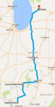 So I’ve been thinking about Plan B. Instead of two days of scooter riding in each direction, I could make the trip to the campsite I’ve reserved as my base at Lincoln State Park in southern Indiana, in a single day, by car. Then spend Monday getting to the eclipse and returning to base, and make the same one-day drive back on Tuesday. Google Maps says it’s 7 hours each way, so I’d assume 8 to allow for traffic.
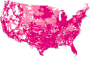 T-Mobile’s network is better than it was, but it still fails a lot outside of cities. I’ve checked their coverage map for Indiana and western Kentucky, and it’s pretty bad. The map, that is. It shows coverage as yes/no question, so looking at it gives you very little sense of the quality of coverage: it’s all solid magenta. The only way to get an assessment of quality is to click on specific locations, where it tells you things like “FAIR… works outdoors, sometimes in buildings”. And there are also areas I’m going through where they admit they don’t cover at all.