Archive for July, 2010

Racing the rain

Thursday, 22nd July 2010; 5:00 pm - Location:

I half-woke this morning around 6:00 and remembered the forecast for today: dry in the first half, but probably raining in the second half. So I pulled out the phone and checked the weather radar. There in Minnesota was a big ugly red blotch creeping its way eastward. I woke up the rest of the way and did some calculations (difficult to do making measurements on a screen that reacts every time you touch it). The rain was a good 10 hours away from me. But it was 6… maybe 7 hours from Grand Rapids, which was where I needed to end up. It was a contest between me and the rain, to see which would get there first.

I didn’t panic, but I didn’t delay. I skipped taking a shower, but brushed my teeth. I broke camp, packed the scooter, and was on the road by 7:00. The route I planned wasn’t intended to be the shortest. Taking the shortest route tends to put you on busy roads, so I’d deliberately chosen to take a more northern route that I hoped would have less traffic. It had the added benefit of adding two more counties to the tally of those I’ve been through. I decided to stick with it.

It turned out to be a good choice, M-57 through Saginaw and Gratiot counties was in good condition, and had little traffic. I got passed every few minutes, usually without the other driver having to wait for oncoming traffic, which is pretty much the best scenario. From time to time I was the only vehicle I could see ahead or behind. There was a constant headwind (the same thing bringing the wind my way), but it only knocked my speed down by a few miles per hour.

I turned south following the Maple River, a bit I’d improvised as a scenic route, and it worked great. But somewhere between M-57 and M-21 I had my first permanent equipment loss of the trip: my water bottle. It was in the end pocket of my over-the-shoulder bag, and was secured by a velcro strap… but came out anyway. If this had happened earlier in the trip, I might have gone back for it, because I know the 5-mile-or-so stretch of road it must have happened on. But not today. It was a nice water bottle, one I’ve been through a lot of camping with, but it’s only a water bottle. And I was in a race.

It was a race I “lost”, but just barely. A mile from home, I saw the first drops of rain on my faceshield, and it continued to sprinkle as I pulled up to the front door. I’d beaten the heavy rain. And more importantly, I’d made it home. Safe.

Meta-Metamora-Hadley

Wednesday, 21st July 2010; 10:30 pm - Location: ,

I made a tactical mistake in planning my route from Algonac (where I returned to the States) to my campground for the night. Like most of my planning blunders it came from not enough knowledge of where I was going. In this case, I steered too close to Metro Detroit. I should have known better, considering that Lake St Clair also borders some of the northern suburbs, but I didn’t think they’d affect traffic as far north as I was going. I got a warning of my mistake when the Maps app on my iPhone overlaid traffic info on one of the streets I was taking. That’s a car-strangled-metropolis-only feature; they don’t even do that for Grand Rapids. And sure enough, as I was trying to make my way northwestward at around 6pm, bunches of commuters were trying to get… somewhere. Just as I was despairing that I’d be tailed the rest of the way by dozens of irate suburbanites unable to pass my 35mph scooter, an onramp for I-94 appeared and sucked them away, and literally a few blocks further I was in Smalltown MI (New Haven, actually) and traffic was sane again.

For a while the scooting was fine, as I rode the backroads of southeast Michigan. Then the opposite blunder happened: In my efforts to avoid busy main roads, I’d routed myself onto a dirt road. A gravelly, pitted dirt road. I backtracked eastward a bit to find a better alternative, and ended up on a not-quite-as-bad dirt road. This one was passable, but not enough. I backtracked east again and found the paved road I had opted against, fearing it would be too busy. It wasn’t. From there it was pavement all the way to Metamora-Hadley State Recreation Area, which I reached as the sun set.

This is another underbooked campground, which I could have skipped the reservation for. For that matter, there was no one on duty when I arrived, so I might have skipped paying altogether. But not only would that be wrong, it’d be Wrong.

The mosquitoes aren’t too bad here: not much worse than the front porch at home. In fact I’m sitting at the site’s picnic table with nothing more than this noon’s bug repellent application, and I’ve only been attacked a dozen times in half an hour. For a while I was watching the fireflies dance around the site, but they’re gone now.

It’s my last night on the road, my last night in a tent. I’m ready to go home tomorrow, but I’m a little bit saddened by it. To have the prospect of losing a glove, or too many commuters itching to pass you, as your biggest concerns, is appealing compared to Life As I Know It.

Regardless, that’s tomorrow’s agenda: get up, break camp, and ride home. With some chance of rain in the afternoon, I may even rush it.

Which sounds sadly similar to the commuters I was dissing a moment ago.

Oh, Canada

Wednesday, 21st July 2010; 5:57 pm

There were no updates during the day today because I went to Rondeau Provincial Park in Ontario, and they don’t have Internet in Canada.

I kid… of course they do, they just don’t have wireless Internet. No wait, they just don’t have AT&T wireless, which is what my US iPhone uses. It will do international data roaming, but who wants to pay for that?

This had implications beyond my blogging ability. No internet means no weather radar, no Fuelly gas mileage log, and (most importantly) no map service.

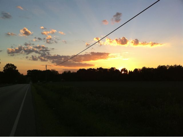
The weather info, I didn’t really need. The day started cloudy and gradually turned to mostly sunny, and I knew that was the prediction before I left. There was a steady W-NW wind that boosted my speed above 40mph on the way out, and slowed me to 30mph the whole way back. {sigh} Unfortunately it didn’t reach to ground level while I was hiking in the woods, which would’ve kept me cool, and help me keep my cool by keeping the flies away from my face.

In theory I might have been able to get in and out of Canada without buying gas. It was 100 miles, round trip. But I didn’t quite have a full tank when I left, and I did some riding around while I was there, and I didn’t want to tap into my reserve fuel. I almost couldn’t find a gas station; nearly the whole route was through farmland, and not even the little dots on the map had stations (or much of anything else). So I had to take a different route back, to go through the village of Blenheim and the city of Chatham-Kent, just to make sure I’d pass by a gas station before I ran out.

Not that finding a different route was necessarily easy, without online map service. But I’d done some advance planning. Before I left home I had printed out maps of each day’s route, just in case of iPhone failure, so I already had a picture of the general area. I also preloaded the Maps app with info for the area I’d be going through by fingering my way through the route; it held this info in its cache for the duration of the ride. What’s neat is that the GPS function (being satellite-based) doesn’t need the internet, so it could update my location, and use the cached map info as a backdrop. I couldn’t zoom in further than I had on the pre-flight walk through, but at least I could tell where I was, which was especially handy trying to make my way on the more complicated route back, through the city of Chatham-Kent.

OK, so enough about the challenges of being offline. Canada:

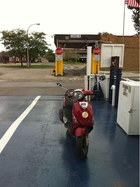
As anyone who’s crossed between Canada and the United States in recent years can tell you, it’s become a long and tedious process, especially when you include the wait to get over the border. Not for me, it wasn’t. I arrived at the Walpole Island/Algonac ferry dock at 8:30am. It’s not hard to find: it’s on the river, in downtown Algonac, just north of the city park where the town’s teenagers go to hang out and be cool when they’re bored. Which seems to be a lot this time of year. I was the only passenger. So when the cars from Canada got off, the attendant waved me on board, took my $4 for the motorcycle and me, and across we went. There was a freighter coming up the river, which we had to stop for, then I disembarked on Walpole Island.

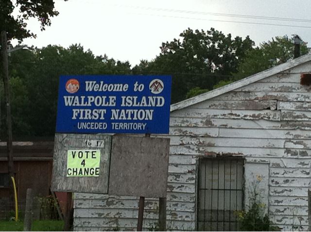
I almost wrote “Walpole Island, Ontario” but I’m not sure that’s strictly true. There’s a sign by the street at the dock that identifies it as “Walpole Island, First Nation, Unceded Territory”. In other words, this is land that the natives managed to hold onto when the Europeans took over; in the U.S., we’d probably call it an “Indian reservation”. Which explains why the ferry crew, the Immigration agents, and most of the people I passed before I left Walpole Island for mainland Ontario were of native ancestry, rather than looking like Dudley Do-Right.

Anyway, the agent for Canadian Immigration quizzed me about the purpose of my visit, and when she wanted more than just “day trip, sight-seeing”, I explained about the big scooter ride and going to Lake Erie but not wanting to ride through Detroit. She asked how long I was staying a couple different ways, apparently to see if I gave inconsistent answers. She asked “Have you ever been denied entry into Canada before?” and that final “before” made me a little nervous, as if it was about to happen for the first time. But she smiled and sent me on my way.

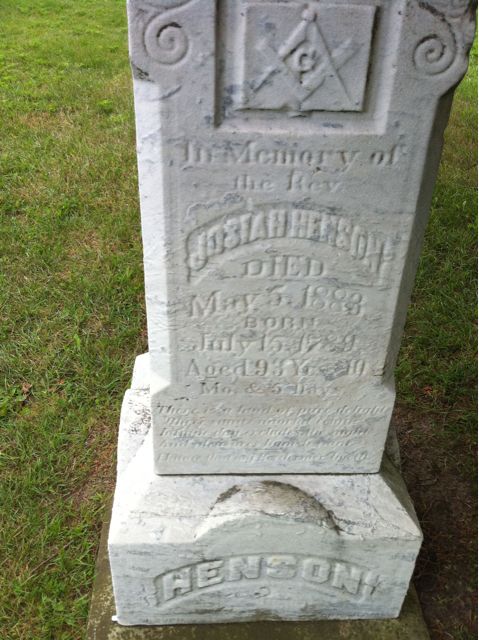
Most of the 50 miles from Walpole Island to the park is farmland, which at least makes for easy navigation: get on the right road and it’ll go in a straight line for miles and miles. The bad news is that the road will run at a diagonal, not north/south. And it will probably be called a “line”, not a “road” or some other familiar term. But I was enticed off the road line by an unexpected sign for “Uncle Tom’s Cabin”. Huh? Time for another ethnic stereotype to be challenged. Josiah Henson, an African-descended former slave and abolitionist whose autobiography provided material for Harriet Beecher Stowe’s novel Uncle Tom’s Cabin, had settled in the county of Kent, Ontario, and this was where he lived and was buried. I stopped at the museum there, which wanted an admission fee to see a video and get a tour of the site, which I declined. The woman running the place was delighted by my scooter and my account of how I’d ridden it from Mackinac, because she’s been wanting to get one herself.

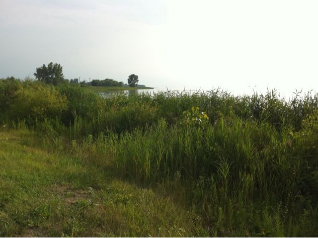
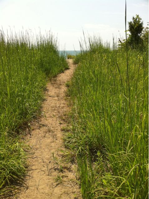
When I arrived at Rondeau Provincial Park, I was relieved that they accepted credit cards for admission, because I had no Canadian currency. (Just a quarter… more about that in a minute.) But my card didn’t have a chip in it, like a proper credit card should, so I had to sign for it; I apologized that I came from a primitive placed called the United States, were we didn’t have that kind of technology. The park is a huge curving peninsula that almost blocks off a secluded bay from Lake Erie. It’s great for bird-watching, but not being a bird-watcher and not having a camera that’s well-suited to it, I didn’t appreciate that like others might. But I had a good hike, including a stretch along the beach, and I got a couple OK photos of circling hawk (among other things). It must have been a nice place, because not only did I reach lake Erie, I spent three hours at the park.

As part of my trip to Canada, I repatriated an elk. The “elk” being a nickname a couple college friends and I gave to Canadian quarters. I see them all the time around here, but I brought one along on this trip to return it to its homeland. Before leaving the park, I dropped it in the dirt. Maybe it will escape into the woodlands. Maybe a Canadian kid will find it and it’ll brighten his day. I’m just glad to have been able to achieve the real objective of this journey: returning a coin to the country in which it was minted.

I ran into a similar credit-card-processing issue when I tried to buy gas at a Petrocanada station: the pump wouldn’t authorize it because the card didn’t have “the chip”. I had a little difficulty understanding the attendant as she explained through the speaker at the pump, because of her accent. Her Asian accent, another example of Ontarian multiculturalism. I have no idea what the actual price of the gas was. Converting from Canadian dollars per liter to U.S. dollars per gallon requires just a little too much mental gymnastics. All I’m sure of is that prices were generally around “0.90”, which feels less, but is probably more.

I arrived at the Walpole Island dock for the return just as the ferry was pulling away, so I had to wait about half an hour for the next one. The U.S. Immigration agent was just as thorough as his Canadian counterpart, asking about the nature of my visit, asking leading questions like “So you went there to meet friends?” to gauge my reaction, and noticing the apparent discrepancy between my account of the long scooter trip and the fact that I wasn’t carrying camping gear (which I explained was at Algonac State Park waiting for my return). He tried to run my plates to see if my vehicle was on any lists, but the number on my moped registration sticker didn’t come up with any hits.

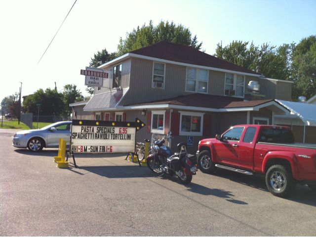
I returned to the camp site and packed up my camping gear. It wasn’t quite 5:00 yet, but I knew I had a good ride ahead of me yet. I still had time for dinner (especially since I hadn’t had lunch), so I stopped at the Roadhouse Bar & Grill on the road out of Algonac. Yes, it’s a bar, but with equal emphasis (depending on time of day) on serving food and a full menu. The lake perch sandwich was delicious and the service was good enough that I didn’t have time to finish this (rather long) entry before my food came, and had to come back to it.

Evening along the St Clair

Tuesday, 20th July 2010; 10:26 pm - Location:

Dinner was at Snoopy’s Dog House in Algonac. I looked for a standard restaurant, really I did. But I didn’t see any other (still in business) local places on the main road, this place advertised “home cooking”, plus there was the “Welcome Bikers” sign. 🙂 It was basically a bar with a grill in the corner. So I needed to have a beer with my Snoopy Burger (prefab beef patty, with bacon, mushrooms, fried onions, and nacho cheese). I managed. 😀 Not a very healthy meal, but I’ve been a good boy On this trip, so I figure it’s OK.

None of the campgrounds I’ve been to has been full. Most have been fairly close to capacity, which means I didn’t really need a reservation, but doing so ensured I got a site to my liking. Sleeper was a little more than half full, with a few sites near mine empty, so I would have been OK there. Algonac, on the other hand, makes me feel a little silly having a reservation. It’s really two campgrounds: one across the street from the river with only token trees, the other back in the woods. I went for the woods. The open campground looks maybe half full, mostly toward the river. The wooded one is nearly vacant; there is not another camper within sight of me (note: there’s a lot of trees and bushes). Which is kinda nice, actually. I suppose it’s more crowded on the weekend, but despite being so close to Detroit, I think it counts as an out-of-the way secret.

One thing I knew to expect with the wooded site is bugs. However, I may have misunderestimated the level of bugs in a wooded site so close to so much water. Most campgrounds on this trip I’ve been OK in dusk or dark with some bug dope, a hat, long pants/sleeves, and a little swatting. But these bugs are hardcore. They may not actually land and bite where I’ve applied insect repellent, but the ear-buzzing gets maddening. So I had no choice but to get in the tent, at only 9:30. I’m secure inside, but the bzzzzz on the other side of that nylon fabric reminds me of Isle Royale (and not in a good way).

End of Lake Huron

Tuesday, 20th July 2010; 7:56 pm - Location:

I’m at the end of the road. Literally.

Riding from Mackinac down the coast of Lake Huron just didn’t feel complete unless I went all the way to the next lake: to Lake St Clair. That means taking the ferry to Harsen’s Island for the last several miles. I couldn’t go all the way to Land’s End, where you can see the St Clair River flow into Lake St Clair; that’s private property. But I rode far enough to see the lake, and that’s good enough for scooting.

The ride also gave me another sighting of a great blue heron. I had no idea when alluded to that bird when I kicked off the blog of this trip (“blue huron”) that ol’ crooked-neck would show up so many times. If I didn’t know better I’d start wondering if this were some kind of spirit quest or something.

Heron, Huron, a river, and two bridges

Tuesday, 20th July 2010; 5:14 pm - Location: ,

Bird-sighting update: in the space of a couple minutes I saw: a crow the size of a small opossum dining on a small opossum by the side of the road; a hawk or some other mid-sized bird of prey, scanning a cornfield from only a few dozen feet up; and to great blue herons taking flight from a marsh, and flying right over me. I was unable to get pictures of any of this, so you’ll have to take my word for it.

As I expected, traffic picked up as I got closer to Port Huron. Less predictably, so did the cloud cover. But it never got worse than a thin overcast, and began to break up when I vote to Port Huron.

The Blue Water Bridges are impossible to miss, at least with the approach I took (taking an alternate parallel road rather than the highway into town). It used to be simple Bridge, but when there are too many cars somewhere, the answer in Michigan (and Ontario) is to build more road. So they built another span, right next to the other. But they deliberately chose a different design for the new one, so they don’t match. I disapprove.

Traffic looked like it was moving reasonably fast for an international bridge. That is, it was like a mild traffic jam. One problem is that all of the international stuff has to be done at the “other” side of the bridge, so the line backs up across it. That, as much as any rules about engine size on the interstate, is why I am not riding my scooter across any bridge to Canada. You see, a moving scooter is inherently stable; it has gyroscopic forces holding it up and moving in a straight line. A stationary scooter is just waiting to fall over.

Across the St Clair River (for that’s what Lake Huron is reduced to at this spot) I could see a handful of Canadian wetbacks trying to get up the nerve to swim across. Actually they were teenagers being typically reckless by jumping from the walkway at the base of the Bridges into the water, swimming downstream a few yards, and climbing out. I half expected the Mounties or whatever to haul them away, but it didn’t happen.

My timing arriving at Algonac State Park was perfectly bad. A family of three (parents and preteen boy) were registering. They had come from Boston. On recumbent bicycles. And are going to Seattle, then LA. They’re raising money for a children’s hospital. By comparison, my journey looks pretty… tame. Oh well.