I went on a practise day trip today. I went from home in Grand Rapids, to Saugatuck (on the lakeshore to the southwest), through Holland, up to Grand Haven (on the lakeshore to the northwest), then home. It was a total of 137 miles (according to the odometer, which isn’t very precise), with an elapsed time of about 5 hours, 20 minutes.

I picked this route for several reasons. First, it’s about the same distance I’m planning to ride on some of my longer days on the big trip, to give me a feel for what that’ll be like. Second, it’s fairly familiar territory, so the chances of getting lost were small and the consequences wouldn’t be all that dire. Third, one of the legs (GR to Saugatuck) will be one I’ll be taking on my weekend shakedown cruise, and another leg (Grand Haven to Grand Rapids) will be the first leg of my expedition, so I can try them out. Fourth, that means the segment in between is a section of the Lake Michigan shoreline that I’ll be skipping on both of those rides, so this is a way to include it. And finally, it was a nice place to ride.
The distance turned out to not be a problem. I took very few breaks along the way (and only really got off the scoot to walk around once), largely to test my endurance. I seem to have held up. Riding a scooter isn’t tiring in the same way that a bicycle is (aerobically), but you gotta sit there with your arms out, holding onto the handlebars, maintaining decent posture, fighting the wind for control. etc. I found myself getting a little cramped at times, and when I stopped to walk around the beach in Grand Haven (about 3.5 hours after I started), I had to limp several yards before my hip started working properly. Yeah, I’m not a kid anymore.
I had a few “firsts” on this trip: I “dropped” my scoot for the first time. “Dropped” or “put down” is the peculiarly nonchalant way that scooterists commonly describe it when their bike ends up on the ground… even if the incident involved them doing a midair cartwheel and skidding along the pavement for an eighth of a mile. In this case, it was almost literally true. I wasn’t sure what the next road was that I should be looking for, so I slowed down and pulled off onto the shoulder to check my directions. The pavement just stopped at the shoulder and the gravel/sand was softer than I was prepared for, and I lost balance. At about 2mph. The only harm done to the scooter was getting dusty and the right rearview mirror getting pushed loose (which happens even from a strong wind), so it needed to be screwed back down. The only harm done to me was a small superficial scrape on my knee (through my jeans), a bruised calf, and a slight abrasion on the palm of my hand (I had taken my gloves off to check the map on my iPhone a couple miles earlier, and neglected to put the gloves back on: lesson re-learned).
The other “first” happened several miles later: I ran out of gas. But that was OK, because I did it on purpose. I wanted to see what kind of range this scooter really has, so I filled the tank to the top before I left, and bungeed a full 1.25-gallon gas can to the rear rack. I was pretty sure I wouldn’t make it the full distance I’d plotted out on the map, which meant that somewhere along the last leg, the tank would empty. I was expecting it when it happened, both because of the distance I’d already gone (116 miles) and because the engine seemed to be gasping a little. Then it cut out, and I coasted to a stop. The tank wasn’t completely empty – I could see a little bit of gasoline sloshing around on the bottom, but it was low enough. So I filled it up again (the gas can holds more than the scooter, apparently), restarted Flash (which took a couple tries before he kept running), and resumed my trip.
Another “first” is that I did in fact get lost. Not seriously, but I missed some turns and each time had to figure out where I was and how to get where I wanted to be. The iPhone was fairly helpful, but not perfect. When you’re away from the city, the first-gen iPhone’s location-detection gets pretty darn vague. Sometimes all it can tell is where the cell tower it’s using is located. But the only place I couldn’t get a signal was when my battery was getting weak, and turning the cell radio off-then-on got me back online. I just had to deal with the fact that it’s slow. And when you’re waiting for it to download street names so you can locate yourself the old-fashioned way on the map, that gets annoying. It’d do in a pinch (assuming cell coverage remained adequate), but I think I’d rather bring a real GPS with me.
As for the ride itself, the route to Saugatuck was mostly roads I’d been on before (either on a bike or in a car), so I knew what to expect. It was some city traffic, followed by a cruise from town to town on the old highway made redundant by I-196 (Chicago Drive), a bit of riding between cornfields, and some more semi-redundant highway (the Blue Star). The main road into downtown Saugatuck was closed (including the bike path, so I couldn’t even walk my scooter), so I didn’t stop there as I’d planned.
The ride from there to Holland was pleasant enough, mostly straight roads cut through the woods on the lee side of the dunes. Because I was hugging the lakeshore, and there’s no way to cross the channel that connects Lake Macatawa to The Lake, I had to take South Shore Drive all the way into downtown Holland (past the pickle plant where Mom worked in olden days), then Ottawa Beach Road back out to Holland State Park. You have to pay to get in to the state park, so I didn’t stop there… then it occurred to me later that I could’ve just bought my annual parking pass today (which I’ll need for the rest of my state park visits), and that would’ve taken care of that. Oh well.
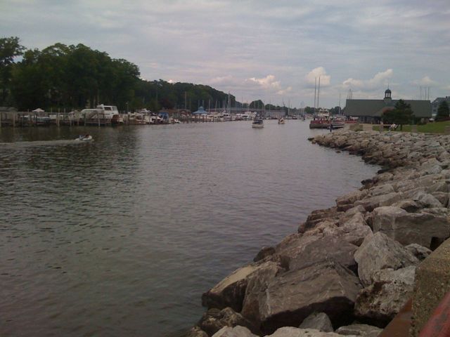
The ride from there to Grand Haven was more curvy and hilly… and at times chilly, because the Lake was just on the other side of the trees and hill to my left. My jacket is designed to keep me cool rather than to keep me warm, and it performed that function very well. There’s lots of nice bike path along this road, but of course I couldn’t use it. When I got to Grand Haven I stopped and walked around the beach a little, snapped some photos to prove I was there, and continued on.

My route from there roughly followed the Grand River, but not very closely after a while, so a good chunk of it (like where I “dropped” my scoot and where I ran out of gas) were on large-grid country roads. I ended up on Lake Michigan Drive, which is the opposite of an obsolete old highway; because it’s the only road to Grand Valley State University’s main middle-of-nowhere campus, it has grown over the past few decades into a big, fast, four-lane, divided highway with a 55mph speed limit. But it’s still moped-legal, and it’s the only way across the Grand River going in that direction. I did OK on it, sometimes slowing to 35mph on hills, as the cars (mercifully few on a Sunday afternoon) breezed past me. Not my favorite road, but way better than an interstate, and it took me directly into GR, where I had a simple ride through the city to my house.
 The biggest excitement was when my odometer rolled over! Well, not completely. I reached 1,000 miles at 114th Avenue, south of Saugatuck. Considering that I’ve had the scooter for only two months, that’s quite a bit of riding. With nearly a quarter of it done in the last 36 hours.